
District of Julfa
Total territory [sq. km] |
926,3 |
Total number of population [th. people] |
48,0 |
City |
1 |
Villages |
22 |
Municipalities |
18 |
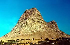
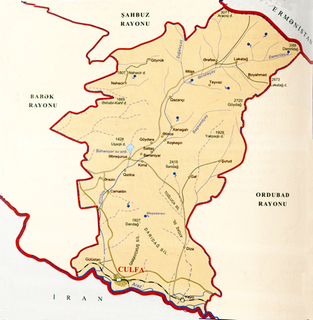 The district of Julfa is located to the east of Nakhchivan city. It is dry, hot in summer and freezing in winter. Total amount of precipitations is about 220-600 mm. There are rivers of Alinja, Gardara and Araz (along the border with Iran). Very beautiful and unique are mountains along the road to Julfa: the geological factor (the composition of layers, age etc.) has influenced their appearance - the mountains resemble huge, dome-shaped, fantastic structures.
The mountains of Julfa are forested, with beech, hornbeam, oak; fauna includes wolves, foxes and hares.
On the bank of the Araz River, there are remainders of ancient structures. These are a caravanserai (13th century) - one of the largest on the territory of Azerbaijan, and the remainders of a bridge dated to the beginning of the 14th century, built by decree of Nakchivan Khan Khakim Ziya Ad-Din. There is the small Gulistan mausoleum (13th century) near the village of Dzhuga and more mausoleums near the village of Der (particularly well preserved is the Tower Mausoleum (15th century). There is also the fortress of Alinja (12th-13th centuries) and a number of other monuments and ancient ruins.
There are many springs in the area (about 40). One of them, located on the slopes of the Daridag Mountain, produces about 500000 liters of strongly mineralized water annually.
 The town of Julfa is located on the bank of the Araz River, on the border with Iran. Located on the opposite bank of the Araz River, almost symmetrical to the Azerbaijani Julfa, is its Iranian namesake. In the past, there was an ancient caravan route connecting Persia with Shirvan, Georgia and Dagestan. Now here is located a border checkpoint.