
Nature and Natural resources
General information
Nakhchivan Autonomous Republic is situated in the South-East of the Transcaucasus plateau. 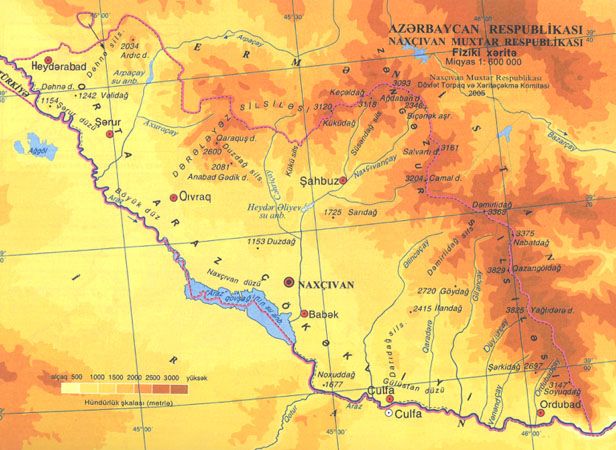 The average height above sea level is 1450 m. The most part of the territory of Nakhchivan Autonomous Republic is surrounded by Zangazur and Daralayaz mountain chains of the Lesser Caucasus.
The highest top is the Gapichig mountain (3904 m). 1/3 of the territory constitutes the plain lands along the Araz river (Sadarak, Sharur, Boyukduz, Kangarli, Nakhchivan, Julfa, Ordubad). There are more than 200 mineral water springs (Daridagh, Badamli, Sirab, Vaykhir and others). The annual precipitation in the plain lands along the Araz river is 200-300 mm but in the high mountainous places is 500-800 mm.
There are 400 big and small rivers in Nakhchivan Autonomous Republic the length of which is 1,8 thousand km. The type of the climate in Nakhchivan Autonomous Republic is mainly dry and continental. The flora of it is very rich. There are 2782 kinds of higher plants and a rather rich animal world.
Geological structure and minerals
Nakhchivan Autonomous Republic drew the attention of geologists and travelers in the middle of the 18th century. Discovering the caves, wells, primary labour tools in the fields of minerals (Duzdagh, Daridagh, Shakardara, Gomur, Guyulugagh, Gizilgaya and so on) once again shows that since ancient times salt, arsenic, copper, gold, sulphur etc. were excavated in the territory of Nakhchivan and also the scientific – descriptive tractats “Javahirnama” was created in the Middle Ages in Azerbaijan. The initial geological investigations and studying of mineral wealths in the region began in the 2nd half of the 18th century. The all-round and systematic investigations of the region began thereafter establishment of Nakhchivan Autonomous Republic.
 The area of Nakhchivan Autonomous Republic is situated in the Nakhchivan tecthonic zone of the Lesser Caucasus from geological point of view. Its geological structure was comprised of the hollow par with 14 km of total thickness and with aboveground volcanic eruptions. Their aboveground appearance gives an opportunity to restore their 400 thousand years old geological data. The wide spread ware stones, construction stones and glassware in the hollow deposits play a great role in the local industry.
The key ore deposits of Nakhchivan are as follows:
1. Pyazbashi gold deposit
This deposit is situated in the area of Ordubad region. It is at 4 km distance North-West of the village Pazmeri at 1800-2700 m height. The key ore minerals are pirites, chalcopirites, bornites, malaxites and free gold. The gold contain in the ores is 1,0-1,9 g/t, the amount of copper is 0,1-1,8. The deposit may be engaged to exploitation.
2. Goydagh copper – porphyry deposit.
This deposit is situated in Julfa region. It is at 2 km distance of the South-East from Bashkand, 2050-2000 m above sea level. The copper and molybdenum spread in ores is unequal and the amount of copper is 1-2,7% and the amount of molybdenum is 0,01-0,08%. The key ore minerals consist of pirites, chalcopirites, phalerites, molybdenum and arising minerals of copper.
The deposit may be engaged to exploitation.
3. Diakhchay copper – porphyry deposit.
This deposit is situated in the region of Ordubad. It is at 1,5 km distance of the North-East from the village of Nus-Nus. 2000 m above sea level. Two technological ore types mainly copper and molybdenum are specific for it. The amount of copper in stokeveric ores (with 70-100 m thickness and which was observed at 1500 m distance) is 0,006-2,25%, in molybdenum 0,01-0,31% and in 55 copper molybdenum ores stretched toward the East and South-East directions with thickness from 2 m to 20 m the amount of molybdenum is 0,01-0,27%, copper is 0,01-0,85%. The key ore minerals are pirites, chalcopirites, molybdenum and arising minerals of copper.
The deposit may be engaged to exploitation.
4. Misdagh copper-porphyry deposit.
This deposit is situated in the region of Ordubad. Is is situated in the upper stream of the Aychangilchay, 3000-3500 m above sea level.
Copper – porphyry oreing is inside and vessel type. The copper in the ore comprises 0,002-2,0%, but molybdenum 0,001-0,02%. The key ore minerals are – pirites, chalcopirites, ouzirite, malaxite and with little amount molybdenum.
The deposit may be engaged to exploitation.
5. Aghyurd gold deposit.
This deposit is situated in the region of Ordubad. It is situated at 2300-2750 m above sea level. The key ore minerals consist of pirites, chalcopirites, molybdenum, arising minerals of ore and little disperside gold.
The amount of gold in ores change between 0,4-11,6% q/t, copper changes between 0,04-1,4%, molybdenum changes between 0,03-0,09%.
The deposit may be engaged to exploitation.
6. Yashillig copper – porphyry deposit.
This deposit is situated at 2,4 km distance in the North-East of the village Pazmari, in the left slope of the river Shiladzochay of Ordubad region and it is at 2200-2500 m above sea level.
The deposit is investigated at 500 m distance with 300m of thickness and the amount of copper in the ores is 0,1-1,4%, molybdenum is 0,1-0,08%.
The key ore minerals are – pirites, chalcopirites, molybdenite, chalcozine, bornites copper arising minerals. The deposit may be engaged to exploitation.
7. Goyhundur copper – porphyry deposit.
This deposit is situated in the region of Ordubad. It is at 2 m distance in the North-East from the village of Pazmari, in the upper part of the Vanandchay river, 2150-2600 m above sea level.
The deposit is come across at 5500-1500 m distance with 5,6-15 m thickness and total width 400-500 m. the amount of copper changes between 0,44-1,33% and the amount of molybdenum changes between 0,001-0,5%.
The key ore minerals are pirites, chalcopirites, molybdenite, covvelin, bornites, cuprite and malachite.
The deposit may be engaged to exploitation.
8. Nasirvaz polymetal deposit.
This deposit is situated around the village of Nasirvaz of Ordubad region and it is 1800-2300 m above sea level.
The oreing process is met from West to East at 2,2 km distance with 60-120 m thickness and zinc comprises 1,2%, lead 1,16%, copper 0,4%.
The key ore minerals are pirites, galenite, sphalerite, chalcopyrite and arising minerals of copper.
The deposit may be engaged to exploitation.
9. Aghdara polymetal deposit.
This deposit is situated at 25 km distance in the North from the Aza railway station of Ordubad region. It is 2100-2550 km above sea level.
The polymetal oreing of it is a layer, lense vessel and inside type. The ore of industrial importance is in the layer form. The amount of lead in the ore is 6,6%, zinc 8,9% and copper is 1,0%.
The deposit was involved to exploitation from 1952.
10. Shakardara gold deposit.
This deposit is situated in the region of Ordubad. It is at 30 km distance in the North-West from the center of the region and it is 1500-2000 m above sea level.
The deposit is situated in the North-West direction and it is met at 1150 m distance with 1,0-8,0 m thickness. The amount of gold in ores is 1,4 g/t, but the amount of the copper is 1,9% .
The key ore minerals consist of pirites, chalcopyrite, sphalerite and arising of copper minerals and free gold.
The deposit may be engaged to exploitation.
11. Goy-gol copper – porphyry deposit.
This deposit is situated in the region of Ordubad. It is at 3 km distance in the North-West from Nurgut village. The deposit is 2800-3554 m above sea level.
The stoke type zones with 60-140 m ore come across from 900 m to 1700 m and the amount of copper comprises 0,47-1,6%, molybdenum amounts 0,01-0,05.
The key ore minerals are pirites, chalcopyrite, bornite, covelmine, arising minerals of copper and molybdenum.
The deposit may be engaged to exploitation.
12. Paraghachay molybdenum deposit.
This deposit is situated around the village of Paragha of Ordubad region. It is 2300-2800 m above sea level. Four cvarsic molybdenum vessels of exploitation objects are known in the deposit.
The key ore minerals are pirites, chalcopyrite and molybdenum.
The deposit was involved to exploitation from 1952.
At the present moment the deposit is partially exploited.
13. Gumushlu polymetal deposit.
This deposit is situated in Sharur region. It is in the down stream of the Arpachay. The deposit is known since the VII century. The amount of lead is 4,5%, but zinc is 0,5% in ores. The mineralogical composition of the ore consists of galenite, serucite, sphalerite, smithenonite and calamine.
The deposit was involved to exploitation from 1954.
14. Daridagh arsenic deposit.
This deposit is situated in Julfa region. It is at 8-9 km distance in the North-East of Julfa city. The ore mass consists of realgar, auripigmente, melnicovite, antimonite and pittisit minerals.
The deposit may be engaged to exploitation.
The key non-ore deposits located in Nakhchivan AR ore as follows:
1. Buzgov travertine deposit
This deposit is in the territory of Babek region. It is situated at 40 km distance in the North-West of Nakhchivan city, at 2 km distance in the North of Ashagi Buzgov village. The area of the deposit is 0,6 km2 and the thickness of the 42,8%. The deposit has been exploited since 1983.
2. Shahtakhti travertine deposit
This deposit is situated in the territory of Sharur at 3 km distance in the South – West of Shahtakhti village. The deposit consists of three parts: the first area is situated in the North-West of Shahtakhti village, the second area is from 1 to 0,7 km of the North-East, but the third area is at 1 km distance from the second in the North-East. The deposit area is 0,8 km2 üith 6,5-22,7 more layer thickness. The block yield comprises 30-45%.
The deposit has been exploited since 1968.
3. Khalaj marbled limestone deposit
This deposit is in the territory of Sharur region. It is situated at 10 km distance in the South-West of Sharur city. The area of the deposit is 0,016 km2. The thickness of the ore layer is 40-70 km, the maximal thickness included to the reserve part is 24 m. The mass capacity of the limestone is 2,33-2,70 t/m3 and the amount of CaCO3 is 98%.
The deposit was exploited till 1990.
4. Garabaghlar travertine deposit
This deposit is situated at 1 km distance in the North-East from Garabaghlar village. The territory of the deposit is 1 km2. The ore thickness is 15-40 m. the block yield of the deposit is 58%. 17,2 m2 travertin is produced from 1m3 block.
The deposit has been exploited since 1984.
5. Oghlangala marbled limestone deposit
This deposit is in the territory of Sharur region. It is situated at 8 km distance in the North-East from the railway station of Sharur.
The ore layer consists of small and middle size fine sand and crosses with calsite vessles of different directions. The amount of Co comprises 51,8%.
The deposit fits to exploitation.
6. Nehram dolomite deposit
This deposit is in Babek region. It is situated at 10 km distance in the South from the village of Nehram namely, at 2 km distance in the North from Darasham railway station. The territory of dolomite is more than 1000 m. this material fits to steady sand, calcinated soda and glass production.
The deposit may be exploited.
7. Nakhchivan Rock-salt deposit
This deposit is in the territory of Babek region. It is situated at 12 km distance in the North-West from the city of Nakhchivan. 5 rock salt layers were discovered in the deposit ut only 2 above ground layers are of industrial importance.
The first layer is situated 105-178 m lower than the above ground and the average thickness of salt is 6 m. The second layer separates from the first layer with the clayey layer of 6-9 m thickness and average thickness of the salt is 8,6. The amount of NaCl comprises 92-98,5%.
The deposit has been utilized since the beginning of the XIX century.
8. Nehram Rock-salt deposit
This deposit is in the territory of babek region. It is situated at 12 km in the South-East from the city of Nakhchivan. The salt thickness in the deposit changes between 43-92 m. NaCl amunts 78-92% in the salt. The deposit was investigated for calcinated soda.
The deposit may be exploited.
9. Gomur sulfur deposit
This deposit is situated in the area of Gomur village of Shahbuz region. The deposit is known since the 60 years of the XIX century. The deposit was not involved to exploitation since uncalculation of sulphur reserve.
10. Paraghachay Andaluzit deposit
This deposit is in the region of Ordubad. It is situated at 9 km distance from the Paraghachay molybdenum mine. The amunt of andaluzit in the rocks comprises 10-30% but sometimes it reaches 65-75%. The deposit was investigated till 10 m in depth. The amount of andaluzit increases toward the depth. According to the initial calculation the capacity of andaluzit is 0,5 mln tons.
The deposit may be engaged to exploitation. Besides this, one may come across rich gravel, sand, clay, gyps deposits everywhere in the territory of Nakhchivan Autonomous Republic.
The Rivers
The Araz river which takes its source in the territory of Turkey and makes the border of Nakhchivan with Turkey and Iran Islamic Republic is the largest river flowing from Nakhchivan. There are about 400 rivers and river branches in the territory of Nakhchivan Autonomous Republic. The Arpachay, the Nakhchivanchay, the Alinjachay, the Gilanchay are regarded the biggest rivers in the territory of the autonomous republic.
The Lakes
The natural lakes of Nakhchivan Autonomous Republic mainly belong to the valleys of Nakhchivanchay and Gilanchay. The Ganligol, the Batabatgol, the Salvartigol, the Goygol are one of the natural lakes of the autonomous republic. The water reservoir named after Heydar Aliyev, the Araz, the Arpachay, the Bananiyar, the Nehram, the Uzunoba and other reservoirs were built in the rivers of Nakhchivan Autonomous Republic.
The mineral waters
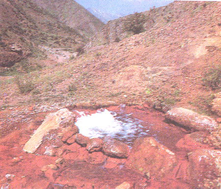 The mineral waters-60 % of the mineral waters reserve of Azerbaijan fall to the share of Nakhchivan Autonomous Republic. Over 250 mineral water sources were stated in 5,5 thousand km2 area of Nakhchivan Autonomous Republic. The mineral waters “Badamli”, “Sirab”, “Vaykhir”, “Gulustan” and “Narzan” are popular in the world.
“Badamli”
The source of this mineral water is situated in the wonderful valley covered with almond wood and vineyard, 1400 m above sea level, at 30 km distance of the city of Nakhchivan, around the village of the same name (Shahbuz region of Nakhchivan AR).
The very place became popular for its carbonate water-narzan springs daily output of which is 2,5 mln liters.
The water contains iodine, bromine, copper, borocic acid.
One of the largest mineral water filling plants in the Caucasus operates here on the basis of the springs under use. “Badamli-5” is a wonderful beverage capable to raise appetite, to better digestive process, to stop thirsty. This water doesn’t have analogy in treating digestive diseases out of resort houses condition.
“Sirab”
“Sirab” is a “Borjomi” type popular healing-beverage water. This water is carbonated, hydrocarbonated-natrium-calcium with 2,0-2,7 g/l total mineral composition. Magnesium, bromine and calcium acids, titium, stonsium were discovered in “Sirab”. On the basis of the utilized sources “Sirab-12” of aromatic  healing-beverage water filling plant operates. This water is used in gastroenteric, urine secretion canal diseases and also in metabolism disturbance. The water source is situated not far from the village of Sirab which is rather popular for the “Dashgala” architectural complex of the Bronze Age.
“Vaykhir”
Vaykhir is the richest deposit with Yesentuki type carbonated salt-alkaline waters and is situated at 17 km distance in the North from the city of Nakhchivan 1400 m above sea level. Daily output of the drilled wells is more than 2 mln liters. This water is carbonated, chloride-hydrocarbonated-natrium with 6,5 g/l total mineral composition. The water is used in gastroenteric diseases, chronical gastritis, metabolism disturbance (sugar diabet, gastritis, diathesis, ocsalanturium) illness.
“Daridagh”
Daridagh – is a rare source existing in nature which is included to the carbonated arsenic mineral waters. It is situated at 8 km distance in the North from the city of Julfa. The investigated reserves are 500 m3. it is of highly mineralized (temperature -52 0S) 21 g/l carbonated CO2 – 1,5 g/l chlorite – hydrocarbonated – natrium composition. In the same time it contains extremely more borium, iodine, bromine, stronsium and lithium. It is advisable to drink in gastroentric, joint diseases. It has an idespensable importance to take a bath in peripheral nerves diseases.
“Nahajir”
“Nahajir” is a health resort place with treatment importance in the North-East of the city of Nakhchivan. It is situated in the slopes of the Nahajir mountain. The base of the health resort reserves comprises carbonated water sources (1,3 g/l free carbonate) magnesium-hydrocarbonated-natrium and water sources with 6 g/l mineralized degree. It gives good results in digestive organs diseases and anaemia illnesses.
“Batabat”
Batabat is the climate health resort zone of healing importance situated in 1700 m above sea level, in the slopes of the Lesser Caucasus at 62 km distance in the North-East from the city of Nakhchivan.
The climate is subtropical, snowy, mild winter, dry and not very hot summer. Togother with the climate condition (aeroheliotherapy) the main healing means are the carbonated, hydrocarbonated, calcium-natrium-magnezium waters with 0,5 g/l mineralized degree. The right water is drunk in treating gastroentric diseases. The lake with sweet water, mnild climate, good scope view and very rich flora belonging to alp meadows impress on human very highly.
“Gomur”
Gomur is a high above mountain climate station. It is situated at 75 km distance of the city of Nakhchivan, 1700 m above sea level.
Very rich mineral water deposits with carbonated salt-alkali composition were discovered here. The climate of this place is mild-cold, but winter is mild and summer is cool. The Gomur health resort zone is of special importance in treating the nerve systems functional diseases, tiredness, gastroentirc and respiratory diseases.
“Sharur”
The Sharur springs are situated near the macadam road, in the South-West of Sirab village. The power of springs (daily output over 1 mln liters) gives an opportunity to bild a healing complex thanks to the waters with carbonated hydrocarbonate-chloride-natrium and with rare microcarbonated complex composition.
The rich mneral waters of Nakhchivan have opportunities to gain advantages in the world market.
Climate
The climate of Nakhchivan is sharp continental. A dry subtropic climate type is met in the territory of Ordubad. The absolute minimum temperature is 31 0C (Darvishlar), the absolute maximum temperature is 44 0C (Julfa).
The climate of the Autonomous Republic is divided into 5 types.
1. The mild hot half desert and dry field climate of summer covers along the Araz lowlands and partly short mountainous areas (600-1400 m). Here the animal average temperature is 10-14 0C, the annual average precipitation till 300 mm, and possible evaporation is 1200-1400 mm.
2. The half desert and dry field climate of dry winter covers the above part of the lower mountainous zone and lower part of the middle mountainous zone (1100-1600 m). The annual average temperature is 80-10 0C, the annual average precipitation is 300-350 mm, possible evaporation is 800-1100 mm.
3. The cold half desert and dry field climate of dry summer covers the above part of the middle mountainous zone (1600-2600 m). The annual average temperature is 60-10 0C and the annual average precipitation changes between 400-800 mm.
4. The cold climate of dry and cool summer only spread in the South-West slope of the Zangazur chain, in the central strip of the height mountainous zone of 2600-3200 m height. The annual average temperature is 10-3 0C.
5. The mountainous Tundura climate covers the height mountainous tops (over 3200 m) of the area. The annual average temperature is 30-8 0C.
The absolute minimum temperature is 31 0C (Darvishlar) in the region but the absolute maximum temperature is 44 0C (Julfa); it is also the most minimum and maximum temperature in the territory of the Azerbaijan Republic. The annual average speed of wind is 2/4 m/s. The annual precipitation is 200-300 mm in the lowlands along the Araz river but in the highest mountainous places it is 500-800 mm.
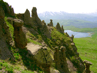
The Flora and Fauna
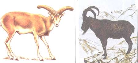
The rare fauna and flora of Azerbaijan are in Nakhchivan Autonomous Republic. Though the territory of Nakhchivan Autonomous Republic comprises 6,2% of the territory of the Republic of Azerbaijan for its kind variety its flora comprises around 60% and fauna 56% of the country.
 7 climate zones out of 11 existing in the world are met in Nakhchivan Autonomous Republic. There are about 3000 plant species, 373 animal sorts, 226 bird kinds in Nakhchivan Autonomous Republic. Rare fauna and flora are protected in the Ordubad State Reservation, Ordubad National Park named after Hasan Aliyev, Shahbuz State Nature Reservation and along the Araz State Nature reservation.
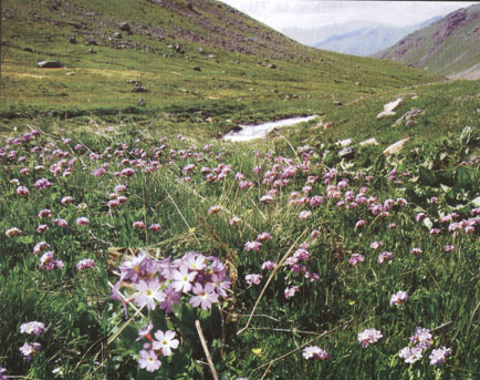
The territory of Nakhchivan Autonomous Republic consists of rich flora and various plants. The flora of Nakhchivan Autonomous Republic is rich compared with other botanic-geographic regions of Azerbaijan. 2782 kinds of supreme plants are met in this region. They in their turns assembled in 773 species and 134 families. 68 of these kinds are cultivated. Wild plants possess 123 families and 697 species. 732 kinds flora are met in the lowlands along the Araz river, 1326 kinds in the middle mountainous and 640 kinds in the highest mountainous areas. The following plants and their types in Nakhchivan Autonomous Republic divide into –deserts and halfdeserts; friganoid and bozgir plants; high pasture, subalp and Alp meadows, Alp piles; woods, oasis, along river small woods; deposit and rock plants, water march plants.
 29 kinds of fishes belonging to the bony fish class were discovered in the rivers and lakes of the Autonomous Republic.
There are 6 kinds of amphibians and 19 kinds of reptiles in Nakhchivan Autonomous Republic.
218 knids of birds out of 366 registered in Azerbaijan live in the territory of the autonomous republic. 61 kinds of mammals are known in the area. 40 kinds of vertebral animals out of 350 kinds living in the autonomous republic were included to the “Red book”.